

The famous newscaster Paul Harvey used to close his popular radio segment saying, “Here’s the rest of the story,” when he would reveal backstory or the cliff-hanger behind a news item or event.
This story is steeped in local history. Click a topic from the list below to learn more background about places and events that were referenced in the narrative.
- The Michillinda Beach Lodge
- Continental Motors
- Mich-Chi-Won Beach
- The Stony Lake Tavern
- Prohibition and Stony Lake, Michigan
- The Civilian Pilot Training Program (CPTP)
- NAS Minneapolis
- Radar and the C.I.C. During WWII
- The NRTS, St. Simons Island, Georgia
- The North Platte Canteen
- Operation Magic Carpet
- Camp Claybanks Army Camp
- Telephone Party Lines
- Silver Lake Sand Dunes
The Michillinda Beach Lodge

The Michillinda Lodge was originally established on a forty-acre parcel of Lake Michigan lakefront property north of Muskegon and was comprised of twenty-three individual lots and a residential beach association. The name Michillinda was derived from the original investors who came from MICHigan, ILLinois and INDianA. A large four-story vacation home was built on one of the lots between 1904 and 1909. It featured eighteen guest rooms as well as a kitchen and a pair of dining rooms that could seat two-hundred guests.
In 1920, a Whitehall resident named Emanuel “Manny” Duttenhofer purchased this home with the intent of making this a summer retreat for his family. He altered his intentions after the death of his wife and opened the building as a public resort, named the Michillinda Beach Tavern. In 1933, it was renamed the Michillinda Beach Lodge to differentiate itself from alcohol-serving saloons. It was under the Duttenhofer proprietorship when the lodge became one of the area’s most frequented resorts.
More of this story can be found at http://www.michillindalodge.com/history
Continental Motors
This company was established in Muskegon in July 1905. During the automobile boom of the early 1900s, Muskegon wanted to expand into that industry. They did so when the Greater Muskegon Chamber of Commerce signed a contract with Ross W. Judson and Arthur W. Tobin to move Continental Motors Manufacturing from Chicago to Muskegon. The contract provided a $12,500 bonus for the company if they employed 125 men for six years. On May 15, 1906, construction began on a two-story factory with 16,000 square feet at the corner of Market and Water Street. For the next four years, Continental purchased surrounding land and built additional buildings to accommodate the growing demand for their engines. Besides building engines, Continental also built transmissions, clutches, marine motors, marine accessories, and other parts. In 1911, Continental Motors also expanded their operations to Detroit where they built a 225,000 square-foot facility to accommodate a contract for building 10,000 motors for the Hudson Motor Car Company. At the time, the plant was the largest in the world that was solely devoted to building engines. When operations commenced at the plant in 1912, Continental moved their administrative offices to Detroit. When their six-year contract with the Greater Muskegon Chamber of Commerce was up in 1912, Continental exceeded the requirements and received the bonus and the original deed to the property.
More
During the Depression, Continental expanded their engine line in order to combat revenue losses from car engine sales. They expanded their aircraft engine line, industrial engine line, and began a venture in Continental-made vehicles to name a few. Realizing that people could not afford expensive vehicles, Continental came out with a less expensive line of full size cars than their competitors. Three models were produced: the Beacon, the Flyer and the Ace. In an effort to keep the cost of the vehicles down, the cars and parts for the cars were to be sold by Continental distributors. However, the production of Continental vehicles was short lived, and after a little over a year, production ended. It was also during this time that Continental revamped their business strategy by consolidating many areas of the business to save money and in 1934, the majority of the business operations in Detroit moved back to Muskegon.
Before World War II began, Continental designed and produced a lighter tank engine, the W670, for the Army Ordnance Corps that could make a tank more mobile and faster. This new engine was an adaptation of an aircraft engine that Continental had already developed. When World War II broke out in Europe, the United States, although neutral, repealed the Arms Embargo Act in 1939, and Great Britain, who needed tank engines, signed a contract with Continental. By the end of 1940, Continental also signed contracts with the US Government to produce engines for tanks and aircraft. The Muskegon plant could not accommodate the space needed to fulfill the contracts and, therefore, renovated the Detroit plant.
In 1941 as the war progressed and the demand for engines grew, Continental expanded their Muskegon and Detroit facilities. With this came an expansion in the workforce as well. Pre-war employment was roughly 700 people; and in 1944 at the peak of production, the workforce was near 23,000 people.
NOTE: Reproduced from: The Teledyne Continental Motors (TCM) Collection, Lakeshore Museum Center Archives, Muskegon, Michigan. Object ID Number X91.074.005. Use Restrictions: None.
Mich-Chi-Won Beach
This is the name of an association of lake properties south of Stony Lake and is still in existence today. It was rumored to have been named according to the main locales where the intended vacationers would come from: Michigan, Chicago and Wisconsin.
Several parcels of land north of Whiskey Creek were purchased by a young couple, Herman and Rose Weber, of Grand Rapids, Michigan in 1925. Their dream was to build a resort that included a golf course and rental cottages. The original plan for the resort got off to a very tumultuous start. Back then, land surveys along Lake Michigan used what was called the “meander line” along the shore as the western boundary of the land. However, when it was re-surveyed for the purpose of the sale, it was discovered the lakeside property line was three hundred feet farther east—well away from the lake’s edge. Because this rendered the land as not being lake frontage, the couple filed a lawsuit, claiming the sellers misrepresented the true description of the land. After several years of litigation, the case ultimately ended up with the Michigan Supreme Court, and the new owners won. This case set legal precedence by removing the meander line in describing lakefront property boundaries. In fact, the ruling even eliminated that “no-man’s land” between the meander line and the water’s edge. Property owners now owned all the way to the shoreline.**
Because of court costs and attorneys’ fees, their dream to build the resort had to be abandoned. Instead, the Webers sold the northern-most acreage to a camp, built two log cabins as vacation rentals, and sold the remaining parcels for building summer cottages.
**From: State of Michigan Supreme Court. John R. Hilt, and Margaret Hilt, Plaintiff’s and Appellants v. Herman H. Weber, and Rose F. Weber, Defendants and Appellees. Docket No. 24, Calendar No. 34,491. Submitted October 8, 1929. Decided December 2, 1930.
The Stony Lake Tavern
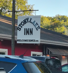
This name was borrowed from the tavern that is still in business today at its original location under the new name of the Stony Lake Inn. The history and description used in the narrative are accurate. It opened in 1925 and in 1988, the name was changed to the Stony Lake Yacht Club as a tongue-in-cheek way to keep up with the neighboring towns of Pentwater and Whitehall; both were situated on lakes and had yacht clubs. The irony is that the tavern is not situated directly on a body of water. The lake, also named Stony Lake, is just “down the road a bit.”
The inspiration for the name change happened when the current owner was asked by a large family if there was a place nearby to get something to eat. When he replied, “Right here! We have good food.” It was when they commented not being “members” the owner wondered how many other potential diners passed by because they thought they had to be a Yacht Club member. Thus began The Stony Lake Inn.
Prohibition and Stony Lake, Michigan
Rumrunning pertains to the illegal trafficking of alcohol over a body of water. Bootlegging takes place over land. Stony Lake and the Stony Lake Channel, like many other waterways along the west coast of Michigan, became a site for rumrunning of illegal alcohol. The secluded shoreline where the Stony Lake Channel flowed into Lake Michigan made it an ideal location for this activity. The vastness of the Great Lakes made it a challenge for law enforcement to detect and capture them.
Perhaps the most colorful character in Stony Lake’s Prohibition history was Charlie Jameson**, a Toledo grifter, rumrunner, bootlegger and racketeer who had ties to the notorious Detroit Purple Gang. He married a Shelby woman and built a cottage on the northeast end of Stony Lake in 1922. He brought liquor across Michigan to the lake and shipped it out through the channel to boats waiting off the Lake Michigan shoreline which then supplied customers throughout the Midwest.
**From: A Stony Lake History. Copyright 1986. The Stony Lake Historians: Alice Kelly, Jess & Marian Thackston, Bill Field, Kay & Jim Orwig, Sarah Orwig. Stony Lake, Michigan.
Civilian Pilot Training Program (CPTP)
The flight training mentioned by the character Petty Officer Radcliff was an actual program organized and administered through the Civil Aeronautics Authority (CAA). The program was signed into law by President Franklin Roosevelt in February 1939. From its inception through June 1942, the Civilian Pilot Training Program (CPTP) produced a vast reservoir of trained private pilots. Of the 907 program centers, 707 were located at colleges and universities. Western State Teacher’s College in Kalamazoo (which later became renamed Western State College of Education) sponsored one of these programs. Theirs began in 1939 along with the establishment of a new two-year vocational aviation mechanics school that was also linked to the newly formed CPTP. The inaugural program in the fall of 1939 enrolled fifty-nine students. Flight training was conducted at Lindbergh Field (later renamed Kalamazoo Airport) or the nearby Austin Lake Airport. The requirements to enter the CPTP were passing a flight physical exam and producing $20.00 for insurance and $4.50 for textbooks.
More about the CPTP
The need for new pilots led the government to turn to aircraft manufacturers, like Piper, to build primary trainer aircraft. The Piper J-3 Cub, which was produced as the L-4 Grasshopper for military purposes, became synonymous with the war effort, specifically after the CPTP was rolled out.”33 This venerable J-3 Cub became the standard training aircraft of the CPTP training fleet. It was a relatively affordable, lightweight, high-winged cabin monoplane. “The demand was so astounding, it seemed that Piper Aircraft could not churn the J-3 out fast enough. Before long, a J-3 Cub was rolling off the line every 20 minutes. Piper claimed that more than 80 percent of the light aircraft used in the early days of the CPTP were Cubs.”
The first level, or elementary CPTP course, included 35 to 50 hours of primary flight training, both dual and solo in the Piper Cub at a local airport and 72 hours of ground school at a college. At the end of the course, those students who satisfactorily completed a written exam and a check flight with a CAA inspector earned a private pilot’s license. No military obligation was assumed at that time, but many graduates eventually went into the army or Navy. Secondary courses consisting of an additional 108 hours of ground school and 40 hours of flight training in more-powerful Waco trainers taught advanced aerobatics and cross-country navigation.
It was claimed the CPTP failed to produce sufficient candidates or adequately prepare them for military aviation. Initially, the percentage of CPTP students who entered the nine primary flight training courses offered by the Army Air Corps in 1941 and 1942 was low compared with the number of students not from the CPTP who entered the same courses. However, a higher percentage of CPTP-trained students (88.2%) were likely to finish the course compared with those not CPTP-trained (56.6%). It was concluded the CPTP was a qualitative rather than a quantitative success. When the United States entered WWII, the nature of the CPTP changed entirely. On December 12, 1941, Executive Order 8974 officially transformed the CPTP into a wartime program. All CAA-sponsored civilian pilot training efforts would be exclusively devoted to the procurement and training of men for ultimate service as military pilots, and the program henceforth fell under the command of the War Training Service (WTS).
**From: Pisano DA. “To Fill the Skies with Pilots: The Civilian Pilot Training Program, 1939-46.” (1993). University of Illinois Press.
NAS Minneapolis
This airbase dates back to October 1928 when it was initially established as a Naval Reserve Aviation Base (NRAB). Prior to December 7, 1941, it consisted of only 139 officers and enlisted personnel. A year later, that number had grown to 436 to support the aviation training of several Navy V-5 college programs located throughout Minnesota. To accommodate their expanding pilot training programs, the Navy began to erect more buildings, install more equipment, assemble more aircraft, and train more mechanics needed to keep the planes airworthy. The NRAB was redesignated as Naval Air Station (NAS) Minneapolis on 01 January 1943. Later, it became designated at NAS Twin Cities. During WWII, the Wold-Chamberlain Airport Terminal still maintained operations for commercial airlines. The Naval training facilities for aviation cadets were located separately at the north end of the field.
Due to the rapid expansion in military aviation training, the Navy also established a new NAAF (Naval Auxiliary Airfield) in December 1942, designated as McInnis Field in nearby South St. Paul. On 7 May 1943, it was officially opened and began operating as a second flight training station to manage the overflow of NAS Minneapolis. The Wold-Chamberlain site was designated as “A” Base and South St. Paul as “B” Base. Each Base managed its own flight training, aircraft maintenance, and housing of ground crews. All the V-5 Cadets, however, were housed at the “A” Base. While both locations would be used for Primary Training operations, most cadets completed their night flying requirements at the “B” Base. On July 20, 1943, McInnis Field was renamed Fleming Field in honor of Marine Captain Richard E. Fleming, a local aviator who died in the Battle of Midway on June 5, 1942.
More anout NAS Minneapolic
The duration of the training was eleven to fourteen weeks with six sections of training. Total flying time amounted to 90-100 hours with 15 hours of dual instruction, a minimum of 55 hours of solo time, and ten hours of check ride tests in the Navy’s tandem two-seat open-cockpit biplane primary trainer, the Stearman N2S. A general outline of the training program at NAS Minneapolis consisted of the following.6
- Primary Dual: Under dual instruction, maneuvers taught were the basics of taxiing, take-offs, climbs, turns, spirals, glides, landings, stalls, spins, and primary emergency procedures. Upon completion of this first stage, the AvCad performed a solo check flight.
- Primary Solo: This phase was fulfilled with both dual instruction and solo demonstration. The AvCad was taught and practiced steeply banked turns, high altitude slips and spirals, spins, wingovers, and reactive emergencies. Instruction included small/short-field landings and slips to a landing.
- Advanced Solo: With both dual instruction and solo demonstration, the AvCad learned loops, the split-S (this is an air combat maneuver used to evade an attack), the snap roll, turns about pylons, precision landings with slips, spin recovery and field procedures.
- Final: With both dual and solo demonstration, this phase provided a general review stressing smoothness, reaction to strange field procedures, instruction in inverted stalls and spins and progressive spins and how to recover from these.
- Formation flying: This phase was also fulfilled with both dual instruction and solo practice.
- Night flying: Dual instruction and solo practice of night flying maneuvers was primarily conducted at the
Fleming Field is known today as South Saint Paul Municipal Airport and is home to the Commemorative Air Force Minnesota Wing and museum which houses numerous restored and airworthy WWII aircraft.
Radar and the C.I.C.
RADAR: It was in the late 1930s when innovations like radio direction finding equipment, radar, and the radar plot for shipboard use provided personnel with combat-related information during the navy’s ‘Fleet Problems.’ This was the title given to a series of over twenty war games exercises to test strategies, strengths and weaknesses during simulated combat. Unfortunately the fragmented nature and lack of timely analysis of that information proved to be of limited strategic benefit. Naval commanders with combat experience deemed the information would be of greater tactical importance if the data could be integrated and quickly processed in one shipboard facility.
More about RADAR
Around 1940, the British were well-ahead of the US with advances in radar technology largely influenced by their need to design and build a system for coastal defense. In September 1940, a delegation from the British Technical and Scientific Mission, also known as the ‘Tizard Mission’, visited the United States to share secret information on radar technology that had military implications. They brought with them a revolutionary device called the resonant cavity magnetron. “Developed by two British scientists at the University of Birmingham, the small device was capable of generating high-powered, centimeter-length pulses of radio waves, also known as microwaves. Its greater power and shorter wavelengths increased detection range, improved accuracy, and enhanced resolution while its small size made the installation of radar sets on aircraft and smaller ships possible.”7,8 While the British excelled in radar research and development, the war created tremendous constraints on their manufacturing capacity. Winston Churchill offered its technology to the United States in exchange for mass-producing it for the war effort. The value of the cavity magnetron was immediately apparent by US scientists at MIT and was quickly put into production at Bell Laboratories.
THE C.I.C. The origin of the Combat Information Center was modeled after the Britain Royal Navy ‘Aircraft Direction Room’, which took pains to provide adequate space in the bridge of its flagships and to establish effective procedures for tracking radar information needed for the admiral to make combat decisions. During the Battle of Midway, CMDR Michael Laing, a British liaison naval officer accompanying Adm. Fletcher aboard the USS YORKTOWN, unobtrusively took notes on the layout and management of Fletcher’s flag bridge and made a number of suggestions to Admiral Nimitz after returning to Pearl Harbor.
More about the C.I.C.
Adm. Nimitz’s staff had already been working on revising the fleet’s radar doctrine aimed at better shipboard facilities and procedures for command and control. Using what he learned from Cmdr. Laing, Nimitz issued Tactical Bulletin 4TB-42 on Thanksgiving Day, 1942, calling for the establishment of a Combat Operations Center on every warship, “where all available sources of combat intelligence can be received, assimilated and evaluated with a minimum of delay.” Admiral King, Chief of Naval Operations, was profoundly impressed with the concept but renamed it the Combat Information Center.
During a conference of navy chiefs on 8 January 1943, Adm. King immediately authorized the installation of CICs on board all surface combatants. Critical facilities and components were identified. King’s staff determined that the CIC should have at least four radar plotting tables; one each for navigation, air contacts, surface contacts, and for fighter direction. It also required extensive interior and exterior communications capabilities, bearing indicators, Plan Position Indicators (PPIs), status/plotting boards and timers. King insisted that it be designed with 30% extra space for future expansion. He even went so far as to design the layout. Space was oriented so that current information provided by radar and sonar scopes along the aft bulkhead, plots and status boards were along the forward bulkhead, and the port and starboard sides were devoted to aircraft or to surface and submarine contacts.
One senior officer who most influenced CIC developments was Rear Admiral Mahlon Tisdale, Commander of Destroyers for the Pacific Fleet. Under his direction, officers Caleb Laning and Joseph Wylie studied the fleet’s use of radar and communications during combat and drafted plans for optimal CIC configurations. Their results were published in the 24-page CIC Handbook for Destroyers on 24 June 1943. It was the first official document that provided a thorough overview of what the CIC could do and how personnel should perform their duties. Nimitz saw to it that this was distributed throughout the entire fleet, and quickly became the essential guidebook for all operational commands. The handbook advocated two main functions of the CIC; to clarify and simplify evaluation and control. It was the commanding officer’s resource for specific tactical or operational data, from which was derived a general summary, an opinion or suggestions. Its control function included target designation, tactical maneuvering, fighter direction and weapons control.
Since the CIC was considered a highly secretive innovation with enormous military value, its access was restricted. Even though the Imperial Japanese Navy (IJN) had radar, it lacked technical sophistication due to neglect by military and naval leadership and lack of R&D collaboration. Allied forces were far ahead in both theory and practice and remained so throughout the war. It rapidly became what the name implied; an “information center.” Information was gathered from all sources, analyzed, evaluated, and passed on to those who needed it. In addition to tracking air and sea contacts and reporting their course and speed, CIC also assists in station keeping, fire control, shore bombardment, navigation, and search-and-rescue. The CIC became the nerve center and eyes of the ship whenever the ship was underway, night, day, fog, rain, snow, or clear skies.14
The development of the CIC created another pressing need: skilled personnel to man these new facilities. The CIC on a destroyer was staffed by roughly fifteen men while a battleship or aircraft carrier required at least double that number. Due to the ever-increasing demand for officers with fighter direction training, Adm. Nimitz established the Pacific Fleet Radar Center at Camp Catlin north of Pearl Harbor. It consolidated all major Pacific Fleet radar training under one command. Its purpose was to instruct naval officers “in all phases of radar utilization and control, but specifically in the organization and operation of Combat Information Centers, and in the technique of fighter direction and evaluation of radar information in surface tactics.” This facility, later renamed the Fighter Director and Combat Information Center School, expanded it curriculum to train personnel for all aspects of CIC duty. This proved a serious bottleneck, with over a quarter of carefully vetted students failing the demanding course. Additional training facilities were set up on the East and West Coasts and CIC training quickly became a part of every ship’s pre-deployment workup. One such facility was the Naval Radar Training School on St. Simons Island (SSI), Georgia.
The NRTS, St. Simons Island, Georgia
The sole purpose of the Naval Air Station facilities and aircraft on St. Simons and at the NRTS would be to support intercept officer/fighter direction training for the school by creating real-life combat scenarios between interceptors and NAS aircraft posing as ‘enemy raiders.’ “Before going overseas, thousands of military personnel rotated through this base using functioning facilities (simulators) patterned after land-based and shipboard Navy Combat Information Centers.” By war’s end, the NRTS at St. Simons Island would have an average of over 500 students at any one time. The staff would include 440 officers, 131 civilian employees, and 595 enlisted personnel.
The NRTS received Naval officers from practically every classification for instruction either as Interceptors or as CIC Watch Officers. Though emphasis was on Fighter Direction, CIC Operations, in general, were thoroughly covered with a trend toward highlighting Surface Navigation as a responsibility of the CIC. The curriculum included courses in air and surface plotting, navigation, communications, radar theory, aircraft performance and identification, tactics, gunnery, weather, fighter direction techniques, and fighter direction problems. A major focus of this training was on directing actual aircraft.
More about the NRTS
Seven fully equipped combat information centers replicating the CICs in various ship types and classes were installed in existing and newly constructed buildings. The centers were fed by live shipboard radars. One of these centers was constructed in The King and Prince Hotel. This resort hotel still exists today on the island. It also had CICs, radars, radios, and other specialized equipment installed to operate as a simulation center. The hotel also provided housing for military personnel.
An operational CIC was a dimly lit compartment and, when fully manned, was rather noisy due to multiple conversations, speakers, and the equipment. Each Radarman wore a sound-powered microphone and headphones, worked at surface, air and auxiliary radar sets and their status boards, and maintained constant communications with their CIC colleagues. Air and surface contacts were continually tracked on their respective plot status boards. The CIC officer and assisting radarman, manning voice communication circuits, huddled over surface, air and auxiliary radar sets, the dead reckoning tracer (DRT) and plotting tables. They analyzed the information gathered which the JA Talker would pass onto the Captain, the Commanding Officer or the Officer of the Deck. Occasionally, voice radio traffic could also be heard transmitted to and from other ships or from the bridge “squawk box.”
In daylight, it was the fighter director’s responsibility to bring the intercept aircraft within a few miles of the target. The main requirement was to be close enough for the pilot to make visual contact, then take over. “In a night intercept the fighter director was expected to guide his pilot’s aircraft astern of the bogey, headed in the same direction, flying just slightly faster and slightly below the target. The goal was to get him close enough to the bogey to be tracked using the cockpit intercept radar.” The Aircraft Control Manual emphasized the challenges of the night fighter director; “…the night controller must be explicit in his direction of the fighter. The confidence of the pilot in the night controller must be absolute, and this is accomplished only where the controller, having accepted responsibility for the control, has fitted himself to the job.”32 Graduating student would have done at least 50 intercepts on simulation trainers plus a minimum of 25 live intercepts.
The North Platte Canteen
This amazing story Stan wrote about in his letter to Lucy is true. The details were borrowed from the book Once Upon a Town: The Miracle of the North Platte Canteen, by Bob Greene. The original story was actually told by Charles Kuralt in one of his CBS News On The Road weekly television series.
The 1940s were a time when trains were the most common mode of transportation. This included moving troops across the country. North Platte was a major rail crossroad. During World War II, American soldiers from every city and walk-of-life rolled through North Platte on troop trains enroute to their ultimate destinations in Europe and the Pacific. At least one hundred trains a day, each loaded with hundreds of soldiers, would stop for a brief period of time to take on water and coal for the steam locomotives. The tiny town, wanting to offer the servicemembers warmth and support, transformed its modest railroad depot into the North Platte Canteen.
Every day of the year, every day of the war, the Canteen – staffed and funded entirely by local volunteers — was open from 5 a.m. until the last troop train of the day pulled away after midnight. Astonishingly, the surrounding Nebraska communities totaling only 12,000 people provided welcoming words, friendship, warm coffee, magazines, and baskets of home-cooked food and treats to more than six million GIs by the time the war ended. What else is remarkable about this story is that feeding these soldiers took place when essential food staples, such as butter, milk, flour, sugar, eggs, and coffee were in short supply due to rationing. Bob Greene’s book is a must read for anyone who enjoys a poignant and heartwarming story that happened at a time when “the home front” of this country was at its best.
Operation Magic Carpet
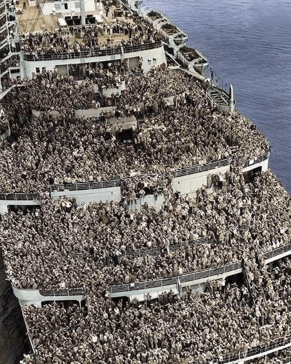
Separated by vast distances, theater, branch of service, sex and race, the journey back to the Home Front at the conclusion of World War II was one of only a handful of incidences universal to nearly all American servicemen who fought and survived the bloodiest conflict in human history. Though lasting only 360 days, Operation Magic Carpet was the largest combined air and sealift ever organized.
Commencing on 10 September 1945, eight days after the formal surrender documents were signed aboard the USS MISSOURI, thousands of war-weary GI’s of the armed forces were transported home from Europe and the Pacific via the Navy’s Magic Carpet carrier service. A total of 18 CV’s (carriers) and CVL’s (light carriers) and approximately 45 CVE’s (escort carriers) were assigned by the Navy to the job of transporting servicemen back to the US. Freed from their wartime duties, these ships were stripped of aircraft and flying personnel and were rigged with special bunks in the hanger decks to accommodate a maximum number of returning veterans.
More about Operation Magic Carpet
In addition to carriers, the task group headquartered out of Pearl Harbor employed hundreds of other ships in the operation: battleships (BBs), cruisers (CAs), attack cargo ships (AKAs), and attack transports (APAs) were among a total of 369 vessels.
Also assisting with the massive and worldwide effort to get service members home were converted Liberty and Victory transport ships and Army transports. The famous British luxury liners, RMS Queen Mary and the RMS Queen Elizabeth were borrowed from the British and used in support of this operation, carrying as many as 15,000 passengers apiece.
Here is another interesting and likely-overlooked story closely associated with Operation Magic Carpet. During the war, many American servicement stationed overseas married local women in the United Kingdom, France, Italy, Australia, New Zealand and the Philippines. “Between 60,000 and 70,000 women wed to American servicement during and immediately after the war were anticipated rejoining their husbands for a new life in the United States. Unfortunately, restrictive immigration policies posed a major roadblock.”8 At war’s end, the US Army attempted to renege on their promises that wives and children of American servicement would be brought to the US. After intense congressional debate and lobbying, the War Brides Act was passed in December, 1945. This removed the immigration quotas that would have prevented many women from entering the United States, especially those from the Philippines and Japan. Thus began Operation War Brides that allowed their entry.
Camp Claybanks Army Camp
This Army National Guard Camp conducted anti-aircraft target practice with live 90-mm and 120-mm anti-aircraft and 50-caliber Browning machine guns over Lake Michigan. It was situated on 434 acres of leased land approximately two miles south of Mich-Chi-Won Beach. Scenic Drive, a gravel road at the time, was closed off at the camp’s north and south perimeters necessitating residents and vacationers to follow numerous detours. During its four-year history, which began in 1953, a total of 2,800 guardsmen and reservists from Michigan, Illinois, Iowa and Indiana were billeted there at various times for antiaircraft training. Firing drills aimed over the lake initially occurred from 7 am to 7 pm, which caused quite the consternation from pleasure boaters and fishermen. It was later restricted from 8 am to 4 pm to allow boater to go out and return during daylight hours. The prevalence of guided missiles for air defense made the camp obsolete. In February 1958 the facility was closed down, the military equipment was removed and all buildings were dismantled.
**From: Sicard JH. “Shelling Lake Michigan: The Short Life of Camp Claybanks.” Historical Society of Michigan. Winter, 2008.
Telephone Party Line “2 Longs, 1 Short ‘
In rural areas, party lines were extremely common during the 1930s and 1940s. Since rural homes were often spaced miles from each other, it was more economical to use fewer wires to accommodate telephone services. However, this meant anywhere from four to ten homes had to share that line. During World War II, party lines were the only method in which many residential subscribers managed to acquire local telephone services.
Multiple types of rings were coded specifically for different households on a shared line. For example, for party one the ring could be a single long ring. For party two there could be two short rings. For party three, it could be one long and one short ring. For party four, it could be a short—long—short ring.
The Silver Lake Sand Dunes
The dunes, a tourist attraction at Silver Lake State Park were formed – and are continually reshaped – by strong winds blowing over Lake Michigan. These dunes have been slowly and steadily creeping in an easterly direction.
In the late 1800s, there used to be a dense pine forest on the site where the dunes are situated. These were logged off which permitted the prevailing northwesterly winds to blow the sand eastward unabated. Between 1938 and 1977, geologists have estimated that drifting sand has covered an additional 468 acres, or roughly three-quarters of a square mile of land and lake.
One cottage owner who has been visiting the area since 1934 reported the rate of travel to have increased from six to eight feet per year to approximately twenty-five feet per year. Within the past half century, the shifting dunes have swallowed several cottages, an apple orchard and is filling in the western shore of Silver Lake.
**From:
- The Flint Journal. December 27, 1968
- The Muskegon Chronicle. January 6, 1980
- The Hart Journal. November 18, 1982.
- Michigan Sand Dunes – A Geological Sketch by Robert W Kelley, Geologist. Dept of Conservation, October 1962.
